Newcastle City Council
Tree preservation zone
There is a problem
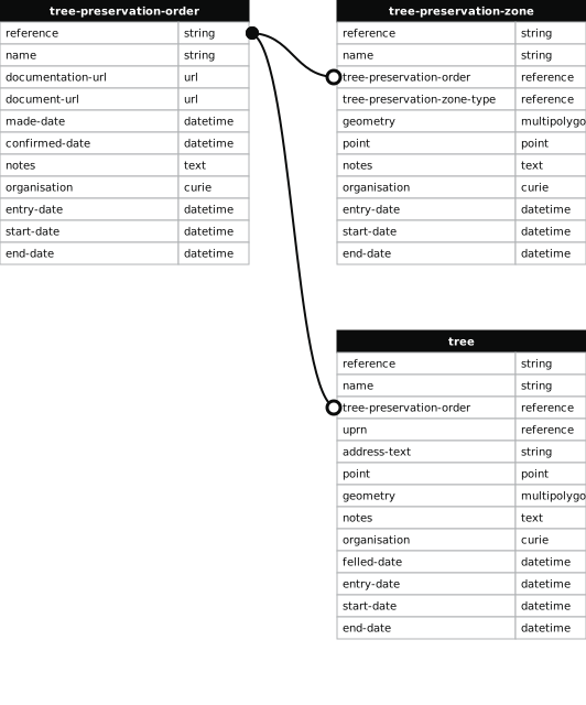
- 1000 entries with tree-preservation-order field must match the reference field in the tree preservation order dataset
High Gosforth Park
- reference
- 1995/017.W10
- name
- High Gosforth Park
- tree-preservation-order
- 1995/017
- tree-preservation-zone-type
- woodland
- geometry
- MULTIPOLYGON (((-1.615051 55.034740,-1.615023 55.034743,-1.614998 55.034748,-1.614971 55.034759,-1.614879 55.034826,-1.614791 55.034830,-1.614787 55.034806,-1.614650 55.034809,-1.614564 55.034948,-1.614526 55.035014,-1.614474 55.035122,-1.614470 55.035153,-1.614500 55.035159,-1.614525 55.035168,-1.614511 55.035281,-1.614174 55.035253,-1.614091 55.035549,-1.614053 55.035690,-1.614163 55.035698,-1.614175 55.035703,-1.614283 55.035711,-1.614316 55.035709,-1.614446 55.035695,-1.614537 55.035681,-1.614895 55.035619,-1.615248 55.035552,-1.615459 55.035502,-1.615791 55.035418,-1.615906 55.035391,-1.615984 55.035366,-1.616031 55.035348,-1.616047 55.035340,-1.616273 55.035283,-1.616737 55.035149,-1.616887 55.035115,-1.617075 55.035077,-1.617318 55.035036,-1.617312 55.035015,-1.617478 55.034995,-1.618287 55.034863,-1.619301 55.034700,-1.619422 55.034657,-1.619552 55.034645,-1.619672 55.034637,-1.619727 55.034628,-1.619868 55.034591,-1.620240 55.034530,-1.620488 55.034491,-1.621148 55.034393,-1.621488 55.034339,-1.622157 55.034240,-1.622195 55.034229,-1.622153 55.034224,-1.622052 55.034195,-1.622007 55.034176,-1.621993 55.034172,-1.621970 55.034168,-1.621926 55.034165,-1.621858 55.034163,-1.621150 55.034167,-1.620897 55.034150,-1.620403 55.034113,-1.620388 55.034096,-1.620349 55.034068,-1.620274 55.034027,-1.620187 55.033987,-1.620108 55.033960,-1.620030 55.033948,-1.619973 55.033946,-1.619901 55.033947,-1.619804 55.033956,-1.619704 55.033975,-1.619679 55.033984,-1.619438 55.034058,-1.619133 55.034155,-1.618726 55.034160,-1.618555 55.034181,-1.618131 55.034237,-1.617688 55.034276,-1.617540 55.034294,-1.616907 55.034363,-1.616770 55.034383,-1.616621 55.034410,-1.616540 55.034434,-1.616482 55.034455,-1.616441 55.034484,-1.616416 55.034510,-1.616282 55.034545,-1.616246 55.034562,-1.616234 55.034571,-1.616231 55.034742,-1.616127 55.035123,-1.616041 55.035130,-1.615641 55.035173,-1.615354 55.035200,-1.615266 55.035210,-1.615212 55.035192,-1.615156 55.035168,-1.615108 55.035145,-1.615061 55.035119,-1.615025 55.035093,-1.614989 55.035062,-1.614980 55.035041,-1.615208 55.034871,-1.615217 55.034857,-1.615223 55.034842,-1.615227 55.034821,-1.615213 55.034798,-1.615191 55.034779,-1.615159 55.034763,-1.615124 55.034749,-1.615088 55.034741,-1.615051 55.034740)))
- point
- POINT (-1.617688 55.034708)
- notes
- These data are update live via a feed to NCC's Tree Managament System, EzyTreev
- entry-date
- 2022-07-01
- start-date
- 1995-01-01
- end-date
How to fix this issue
Your data is missing a tree-preservation-order.
The Tree preservation zone guidance explains how to fix the issue:
tree-preservation-order
The reference for the tree preservation order that covers this zone.
How to improve Newcastle City Council’s data
- Fix the errors indicated
- Use the check service to make sure the data meets the standard
- Publish the updated data on the endpoint URL